
FCCInfo.com
A Service of Cavell, Mertz & Associates, Inc.
(855) FCC-INFO
|
|
KNIC-DT from 08/08/2005 |
Virtual Channel 17 |
|
|||||||||||||||||||
|
|
Repacking Information: No changes Status: License Application Accepted: 10/19/2009 License Expires: 08/01/2022 File Number: BLCDT-20091019ADG Prefix Type: This is a License for a commercial digital TV station FCC Website Links: LMS Facility Details This Application Other KNIC-DT Applications Including Superseded Applications Mailing Address Correspondence for KNIC-DT Correspondence related to application BLCDT-20091019ADG Service Contour - Open Street Map or USGS Map (41 dBu) Service Contour - KML / Google Earth (41 dBu) Public Inspection Files Rabbit Ears Info Search for KNIC-DT Site Location: 29-41-48.6 N 98-30-45.8 W (NAD 83) Site Location: 29-41-47.8 N 98-30-44.7 W (Converted to NAD 27) ERP: 1000 kW Polarization: Elliptically polarized HAAT: 200 m (656 ft.) Electrical Beam Tilt: 0.75 degrees R/C AGL: 168.1 m (552 ft.) R/C AMSL: 551.1 m (1808 ft.) Site Elevation: 383 m. (1257 ft.) Height Overall*: 180.5 m (592 ft.) (* As Filed In This Application, may differ from ASR Data, Below.) Directional Antenna - Antenna Make/Model: Electronics Research Inc. ATW30H3-ESSX-18H Antenna ID: 87498 Polarization: Elliptically polarized | |||||||||||||||||||||
| Antenna Data for Antenna Id: 87498 KNIC-DT DT File: BLCDT-20091019ADG Electronics Research Inc. - ATW30H3-ESSX-18H Service: DT Standard Pattern: Y | 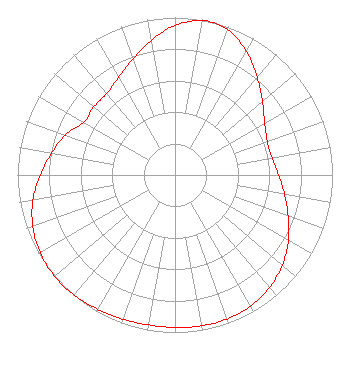 | |||||||||||||||||||||
| Azimuth | Ratio | Azimuth | Ratio | Azimuth | Ratio | Azimuth | Ratio | |||||||||||||||
| 0 | 0.950 | 10 | 0.997 | 12 | 1.000 | 20 | 0.981 | |||||||||||||||
| 30 | 0.907 | 40 | 0.812 | 50 | 0.725 | 60 | 0.658 | |||||||||||||||
| 70 | 0.623 | 80 | 0.626 | 90 | 0.658 | 100 | 0.706 | |||||||||||||||
| 110 | 0.765 | 120 | 0.831 | 130 | 0.890 | 140 | 0.933 | |||||||||||||||
| 150 | 0.961 | 160 | 0.973 | 170 | 0.973 | 180 | 0.968 | |||||||||||||||
| 190 | 0.967 | 200 | 0.973 | 210 | 0.984 | 220 | 0.995 | |||||||||||||||
| 230 | 0.999 | 240 | 0.989 | 250 | 0.961 | 260 | 0.916 | |||||||||||||||
| 270 | 0.857 | 280 | 0.795 | 290 | 0.742 | 300 | 0.669 | |||||||||||||||
| 310 | 0.672 | 320 | 0.675 | 330 | 0.715 | 340 | 0.783 | |||||||||||||||
| 350 | 0.868 | |||||||||||||||||||||
Structure Registration Number 1245311 Structure Type: TOWER Registered To: Univision Television Group, Inc. Structure Address: South End Of Hogan Drive San Antonio, TX County Name: Bexar County ASR Issued: 10/18/2007 Date Built: 08/21/2006 Site Elevation: 383 m (1257 ft.) Structure Height: 180.5 m (592 ft.) Height Overall: 180.5 m (592 ft.) Overall Height AMSL: 563.5 m (1849 ft.) FAA Determination: 08/10/2004 FAA Study #: 2004-ASW-3587-OE FAA Circular #: 70/7460-1K Paint & Light FAA Chapters: 4, 9, 12 PRIOR STUDY 2003-ASW-663-OE 29-41-48.6 N 98-30-45.8 W (NAD 83) 29-41-47.8 N 98-30-44.7 W (Converted to NAD 27) |
101 Constitution Avenue, Nw, Suite 800w Washington, WA 20001 Phone: 310-348-3600 Corporation | Date: 10/19/2009 Application Certifier TELEFUTURA PARTNERSHIP OF SAN ANTONIO 5999 Center Drive Los Angeles, CA 90045 Applicant KARL D. LAHM, P.E. Univision Management Co. P.o. Box 647 Lake Villa, IL 60046 DIRECTOR, RF SYSTEMS ENGINEERING ROBERT M. SHERMAN, ESQ. Covington & Burling Llp 1201 Pennsylvania Avenue, Nw Washington, DC 20004 | ||||||||||||||||||||
| ||||||||||||||||||||||