
FCCInfo.com
A Service of Cavell, Mertz & Associates, Inc.
(855) FCC-INFO
|
|
W35CS-D from 08/05/2008 W35CS-D from 09/21/2005 |
|
|
||||||||||||||||
|
|
Status: License Application Accepted: 08/03/2009 License Expires: 10/01/2020 File Number: BLDTL-20090803ADY Prefix Type: This is BLDTL FCC Website Links: LMS Facility Details This Application Other W35CS-D Applications Including Superseded Applications Mailing Address Correspondence for W35CS-D Correspondence related to application BLDTL-20090803ADY Service Contour - Open Street Map or USGS Map (51 dBu) Service Contour - KML / Google Earth (51 dBu) Rabbit Ears Info Search for W35CS-D Site Location: 38-34-33.0 N 75-20-17.0 W (NAD 83) Site Location: 38-34-32.6 N 75-20-18.3 W (Converted to NAD 27) ERP: 6.5 kW R/C AGL: 110 m (361 ft.) R/C AMSL: 119.4 m (392 ft.) Emission Mask: Simple Site Elevation: 9.4 m. (31 ft.) Height Overall*: 121.9 m (400 ft.) (* As Filed In This Application, may differ from ASR Data, Below.) Directional Antenna - Antenna Make/Model: Scala PR-450 ARRAY Antenna ID: 92300 | ||||||||||||||||||
| Antenna Data for Antenna Id: 92300 W35CS-D LD File: BLDTL-20090803ADY Scala - PR-450 ARRAY Service: LD Standard Pattern: Y Pattern and Field Values Include a 125° Clockwise Rotation | 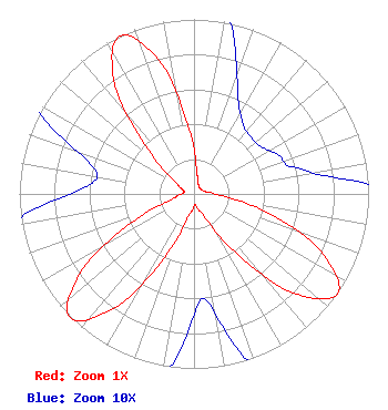 | ||||||||||||||||||
| Azimuth | Ratio | Azimuth | Ratio | Azimuth | Ratio | Azimuth | Ratio | ||||||||||||
| 5 | 0.150 | 15 | 0.090 | 25 | 0.060 | 35 | 0.049 | ||||||||||||
| 45 | 0.046 | 55 | 0.047 | 65 | 0.053 | 75 | 0.059 | ||||||||||||
| 85 | 0.090 | 95 | 0.180 | 105 | 0.460 | 115 | 0.815 | ||||||||||||
| 125 | 1.000 | 135 | 0.800 | 145 | 0.400 | 155 | 0.150 | ||||||||||||
| 165 | 0.090 | 175 | 0.060 | 185 | 0.090 | 195 | 0.150 | ||||||||||||
| 205 | 0.400 | 215 | 0.800 | 225 | 1.000 | 235 | 0.800 | ||||||||||||
| 245 | 0.400 | 255 | 0.150 | 265 | 0.090 | 275 | 0.060 | ||||||||||||
| 285 | 0.060 | 295 | 0.090 | 305 | 0.150 | 315 | 0.400 | ||||||||||||
| 325 | 0.800 | 335 | 1.000 | 345 | 0.800 | 355 | 0.400 | ||||||||||||
Structure Registration Number 1032227 Structure Type: TOWER Registered To: CTI Towers Assets II, LLC Structure Address: Lakeview Road At Phillips Hill Millsboro, DE County Name: Sussex County ASR Issued: 12/07/2022 Date Built: 01/01/1974 Site Elevation: 9.4 m (31 ft.) Structure Height: 115.8 m (380 ft.) Height Overall: 121.9 m (400 ft.) Overall Height AMSL: 131.3 m (431 ft.) FAA Determination: 11/05/1974 FAA Study #: 74-EA-1212-OE Paint & Light FAA Chapters: 1, 3, 12, 21 RED LIGHTS/PAINT 38-34-33.0 N 75-20-17.0 W (NAD 83) 38-34-32.6 N 75-20-18.3 W (Converted to NAD 27) |
Hurst, TX 76054 Phone: 214-770-7770 Corporation | Date: 08/03/2009 Application Certifier EICB-TV EAST, LLC 406 Copeland Drive Cedar Hill, TX 75104 Applicant B. W. ST. CLAIR 2355 Ranch Drive Westminster, CO 80234 ENGINEERING CONSULTANT DR. RANDY WEISS Eicb-tv East, Llc | |||||||||||||||||