
FCCInfo.com
A Service of Cavell, Mertz & Associates, Inc.
(855) FCC-INFO
|
|
KXMA-TV from 03/30/1983 KXMA-TV from 12/27/1979 |
Virtual Channel 2 |
|
|||||||||||||||||||
|
|
Repacking Information: No changes Status: License Application Accepted: 07/15/2009 License Expires: 04/01/2022 File Number: BLCDT-20090715AHZ Prefix Type: This is a License for a commercial digital TV station FCC Website Links: LMS Facility Details This Application Other KXMA-TV Applications Including Superseded Applications Mailing Address Correspondence for KXMA-TV Correspondence related to application BLCDT-20090715AHZ Service Contour - Open Street Map or USGS Map (41 dBu) Service Contour - KML / Google Earth (41 dBu) Public Inspection Files History Cards for KXMA-TV Rabbit Ears Info Search for KXMA-TV Site Location: 46-43-35.0 N 102-54-59.0 W (NAD 83) Site Location: 46-43-35.0 N 102-54-57.4 W (Converted to NAD 27) ERP: 150 kW Polarization: Horizontally polarized HAAT: 217 m (712 ft.) Electrical Beam Tilt: 0.75 degrees R/C AGL: 140 m (459 ft.) R/C AMSL: 1033 m (3389 ft.) Site Elevation: 893 m. (2930 ft.) Height Overall*: 176 m (577 ft.) (* As Filed In This Application, may differ from ASR Data, Below.) Directional Antenna - Antenna Make/Model: DIELECTRIC 881-24 Antenna ID: 90602 Polarization: Horizontally polarized | |||||||||||||||||||||
| Antenna Data for Antenna Id: 90602 KXMA-TV DT File: BLCDT-20090715AHZ DIELECTRIC - 881-24 Service: DT Standard Pattern: Y | 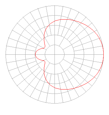 | |||||||||||||||||||||
| Azimuth | Ratio | Azimuth | Ratio | Azimuth | Ratio | Azimuth | Ratio | |||||||||||||||
| 0 | 0.677 | 10 | 0.722 | 20 | 0.761 | 30 | 0.800 | |||||||||||||||
| 40 | 0.844 | 50 | 0.890 | 60 | 0.934 | 70 | 0.969 | |||||||||||||||
| 80 | 0.992 | 90 | 1.000 | 100 | 0.992 | 110 | 0.969 | |||||||||||||||
| 120 | 0.934 | 130 | 0.890 | 140 | 0.844 | 150 | 0.800 | |||||||||||||||
| 160 | 0.761 | 170 | 0.722 | 180 | 0.677 | 190 | 0.615 | |||||||||||||||
| 200 | 0.531 | 210 | 0.428 | 220 | 0.323 | 230 | 0.251 | |||||||||||||||
| 240 | 0.257 | 250 | 0.316 | 260 | 0.370 | 270 | 0.391 | |||||||||||||||
| 280 | 0.370 | 290 | 0.316 | 300 | 0.257 | 310 | 0.251 | |||||||||||||||
| 320 | 0.323 | 330 | 0.428 | 340 | 0.531 | 350 | 0.615 | |||||||||||||||
Structure Registration Number 1037970 [ASR Heights Differ from KXMA-TV Application] Structure Type: TOWER Registered To: PRAIRIE PUBLIC BROADCASTING INC Structure Address: 16.9 Km S 937 Km W Dickinson, ND County Name: Stark County ASR Issued: 05/17/2010 Date Built: 07/21/2009 Site Elevation: 893.4 m (2931 ft.) Structure Height: 152.4 m (500 ft.) Height Overall: 171.1 m (561 ft.) Overall Height AMSL: 1064.5 m (3492 ft.) FAA Determination: 05/13/2010 FAA Study #: 2009-AGL-3955-OE Paint & Light FAA Chapters: 1, 3, 4, 13, 21 Continue As Is OM&L = PAINT/RED LIGHTS 46-43-35.0 N 102-54-59.0 W (NAD 83) 46-43-35.0 N 102-54-57.4 W (Converted to NAD 27) |
545 E. John Carpenter Freeway Suite 700 Irving, TX 75062 Phone: 972-373-8800 Corporation | Date: 07/15/2009 Application Certifier REITEN TELEVISION, INC. 2121 Second Street, Se P.o. Box 1686 Minot, ND 58702-1686 Applicant JEREMY D. RUCK, PE D.l. Markley & Associates, Inc. 2104 West Moss Avenue Peoria, IL 61604 CONSULTING ENGINEER BRENDAN HOLLAND Davis Wright Tremaine Llp | ||||||||||||||||||||
| ||||||||||||||||||||||