
FCCInfo.com
A Service of Cavell, Mertz & Associates, Inc.
(855) FCC-INFO
|
|
WSOT-LD from 10/20/1995 WSOT-LD from 09/21/1990 |
|
|
||||||||||||||||
|
|
Status: License Application Accepted: 12/12/2011 License Expires: 08/01/2021 File Number: BLDTL-20111212AGP Prefix Type: This is BLDTL FCC Website Links: LMS Facility Details This Application Other WSOT-LD Applications Including Superseded Applications Mailing Address Correspondence for WSOT-LD Correspondence related to application BLDTL-20111212AGP Service Contour - Open Street Map or USGS Map (51 dBu) Service Contour - KML / Google Earth (51 dBu) Rabbit Ears Info Search for WSOT-LD Site Location: 40-39-18.1 N 85-37-22.9 W (NAD 83) Site Location: 40-39-17.9 N 85-37-23.0 W (Converted to NAD 27) ERP: 10 kW Electrical Beam Tilt: 1.75 degrees R/C AGL: 148 m (486 ft.) R/C AMSL: 421.4 m (1383 ft.) Emission Mask: Stringent Site Elevation: 273.4 m. (897 ft.) Height Overall*: 152.4 m (500 ft.) (* As Filed In This Application, may differ from ASR Data, Below.) Directional Antenna - Antenna Make/Model: Andrew AL8 Antenna ID: 16352 | ||||||||||||||||||
| Antenna Data for Antenna Id: 16352 WSOT-LD LD File: BLDTL-20111212AGP Andrew - AL8 Service: LD Standard Pattern: Y Pattern and Field Values Include a 285° Clockwise Rotation | 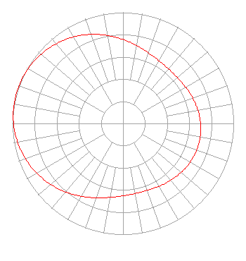 | ||||||||||||||||||
| Azimuth | Ratio | Azimuth | Ratio | Azimuth | Ratio | Azimuth | Ratio | ||||||||||||
| 5 | 0.733 | 15 | 0.692 | 25 | 0.662 | 35 | 0.644 | ||||||||||||
| 45 | 0.639 | 55 | 0.646 | 65 | 0.661 | 75 | 0.678 | ||||||||||||
| 85 | 0.694 | 95 | 0.705 | 105 | 0.709 | 115 | 0.705 | ||||||||||||
| 125 | 0.694 | 135 | 0.678 | 145 | 0.661 | 155 | 0.646 | ||||||||||||
| 165 | 0.639 | 175 | 0.644 | 185 | 0.662 | 195 | 0.692 | ||||||||||||
| 205 | 0.733 | 215 | 0.780 | 225 | 0.829 | 235 | 0.876 | ||||||||||||
| 245 | 0.918 | 255 | 0.953 | 265 | 0.979 | 275 | 0.995 | ||||||||||||
| 285 | 1.000 | 295 | 0.995 | 305 | 0.979 | 315 | 0.953 | ||||||||||||
| 325 | 0.918 | 335 | 0.876 | 345 | 0.829 | 355 | 0.780 | ||||||||||||
Structure Registration Number 1201925 Structure Type: TOWER Registered To: Sunnycrest Media, Inc. Structure Address: 9342 West 1200 South 35 Marion, IN County Name: Huntington County ASR Issued: 08/24/1999 Date Built: 01/30/2000 Site Elevation: 273.4 m (897 ft.) Structure Height: 151.4 m (497 ft.) Height Overall: 152.4 m (500 ft.) Overall Height AMSL: 425.8 m (1397 ft.) FAA Determination: 08/04/1999 FAA Study #: 99-AGL-2356-OE FAA Circular #: 70/7460-1J Paint & Light FAA Chapters: 3, 4, 5, 13 Removed expiration date from determination. Scenario 1./jjs/case#635066 40-39-18.1 N 85-37-22.9 W (NAD 83) 40-39-17.9 N 85-37-23.0 W (Converted to NAD 27) |
2172 W Chapel Pike Marion, IN 46952 Phone: 765-668-1014 Not-for-Profit | Date: 12/12/2011 Application Certifier SUNNYCREST BAPTIST CHURCH 2172 Chapel Pike Marion, IN 46952 Applicant KEVIN T. FISHER 2237 Tacketts Mill Drive Suite A Lake Ridge, VA 22192 ENGINEERING CONSULTANT PAUL J. FELDMAN, ESQUIRE Fletcher, Heald & Hildreth, Plc | |||||||||||||||||