
FCCInfo.com
A Service of Cavell, Mertz & Associates, Inc.
(855) FCC-INFO
|
|
K35LF-D from 08/25/1995 |
|
|
||||||||||||||||
|
|
Status: License Application Accepted: 08/29/2014 License Expires: 12/01/2022 File Number: BLDTT-20140829ACM Prefix Type: This is BLDTT FCC Website Links: LMS Facility Details This Application Other K35LF-D Applications Including Superseded Applications Mailing Address Correspondence for K35LF-D Correspondence related to application BLDTT-20140829ACM Service Contour - Open Street Map or USGS Map (51 dBu) Service Contour - KML / Google Earth (51 dBu) Rabbit Ears Info Search for K35LF-D Site Location: 40-43-35.1 N 123-58-30.7 W (NAD 83) Site Location: 40-43-35.6 N 123-58-26.5 W (Converted to NAD 27) ERP: 15 kW Electrical Beam Tilt: 1.75 degrees R/C AGL: 34 m (112 ft.) R/C AMSL: 838 m (2749 ft.) Emission Mask: Stringent Site Elevation: 804 m. (2638 ft.) Height Overall*: 67 m (220 ft.) (* As Filed In This Application, may differ from ASR Data, Below.) Directional Antenna - Antenna Make/Model: Electronics Research Inc. AL8E-35-PL Antenna ID: 113225
| ||||||||||||||||||
| Antenna Data for Antenna Id: 113225 K35LF-D LD File: BLDTT-20140829ACM Electronics Research Inc. - AL8E-35-PL Service: LD Standard Pattern: Y Pattern and Field Values Include a 290° Clockwise Rotation | 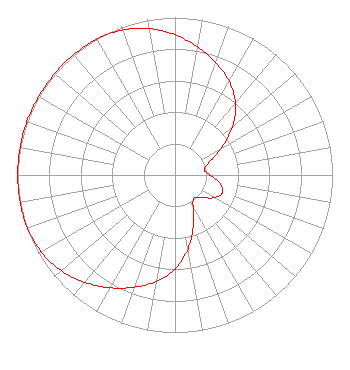 | ||||||||||||||||||
| Azimuth | Ratio | Azimuth | Ratio | Azimuth | Ratio | Azimuth | Ratio | ||||||||||||
| 0 | 0.890 | 10 | 0.826 | 20 | 0.758 | 30 | 0.687 | ||||||||||||
| 40 | 0.597 | 50 | 0.476 | 60 | 0.340 | 70 | 0.229 | ||||||||||||
| 80 | 0.188 | 90 | 0.222 | 100 | 0.287 | 110 | 0.322 | ||||||||||||
| 120 | 0.287 | 130 | 0.222 | 140 | 0.188 | 150 | 0.229 | ||||||||||||
| 160 | 0.340 | 170 | 0.476 | 180 | 0.597 | 190 | 0.687 | ||||||||||||
| 200 | 0.758 | 210 | 0.826 | 220 | 0.890 | 230 | 0.944 | ||||||||||||
| 240 | 0.979 | 250 | 0.996 | 260 | 0.999 | 270 | 0.999 | ||||||||||||
| 280 | 0.999 | 290 | 1.000 | 300 | 0.999 | 310 | 0.999 | ||||||||||||
| 320 | 0.999 | 330 | 0.996 | 340 | 0.979 | 350 | 0.944 | ||||||||||||
Structure Registration Number 1011979 Structure Type: Registered To: PWM, Inc. Structure Address: 1959 Barry Rd Kneeland, CA County Name: Humboldt County ASR Issued: 08/04/2021 Date Built: 09/19/1996 Site Elevation: 804 m (2638 ft.) Structure Height: 61 m (200 ft.) Height Overall: 67 m (220 ft.) Overall Height AMSL: 871 m (2858 ft.) FAA Determination: 06/01/1998 FAA Study #: 98-AWP-1509-OE Paint & Light FAA Chapters: NONE 40-43-35.1 N 123-58-30.7 W (NAD 83) 40-43-35.6 N 123-58-26.5 W (Converted to NAD 27) |
C/o Miles S. Mason, Esq. 1200 Seventeenth Street, Nw Washington, DC 20036 Phone: 202-663-8195 Limited Liability Company | Date: 08/29/2014 Application Certifier CALIFORNIA BROADCASTING, INC. Empire State Building 350 Fifth Avenue, Suite 5340 New York, NY 10018 Applicant JOSEPH M. DAVIS, P.E. Chesapeake Rf Consultants, Llc 207 Old Dominion Road Yorktown, VA 23692 CONSULTING ENGINEER EVE R. POGORILER Covington & Burling Llp | |||||||||||||||||