
FCCInfo.com
A Service of Cavell, Mertz & Associates, Inc.
(855) FCC-INFO
|
|
|
Virtual Channel 9 |
|
||||||||||||||||
|
|
Repacking Information: No changes Status: License Application Accepted: 04/23/2003 License Expires: 06/01/2022 File Number: BLEDT-20030423ABE Prefix Type: This is a license for a noncommercial educational digital TV station FCC Website Links: LMS Facility Details This Application Other KOOD Applications Including Superseded Applications Mailing Address Correspondence for KOOD Correspondence related to application BLEDT-20030423ABE Service Contour - Open Street Map or USGS Map (41 dBu) Service Contour - KML / Google Earth (41 dBu) Public Inspection Files History Cards for KOOD Rabbit Ears Info Search for KOOD Site Location: 38-46-16.0 N 98-44-17.0 W (NAD 83) Site Location: 38-46-16.0 N 98-44-15.7 W (Converted to NAD 27) ERP: 496 kW Polarization: Horizontally polarized HAAT: 304 m (997 ft.) Electrical Beam Tilt: 0.75 degrees R/C AGL: 293 m (961 ft.) R/C AMSL: 854 m (2802 ft.) Site Elevation: 561 m. (1841 ft.) Height Overall*: 342 m (1122 ft.) (* As Filed In This Application, may differ from ASR Data, Below.) Directional Antenna - Antenna Make/Model: Andrew ATW26H3-HSTX-16H Antenna ID: 43521 Polarization: Horizontally polarized | ||||||||||||||||||
| Antenna Data for Antenna Id: 43521 KOOD DT File: BLEDT-20030423ABE Andrew - ATW26H3-HSTX-16H Service: DT Standard Pattern: Y | 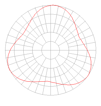 | ||||||||||||||||||
| Azimuth | Ratio | Azimuth | Ratio | Azimuth | Ratio | Azimuth | Ratio | ||||||||||||
| 0 | 0.990 | 5 | 1.000 | 10 | 0.990 | 20 | 0.952 | ||||||||||||
| 30 | 0.886 | 40 | 0.809 | 50 | 0.743 | 60 | 0.705 | ||||||||||||
| 65 | 0.694 | 70 | 0.705 | 80 | 0.743 | 90 | 0.809 | ||||||||||||
| 100 | 0.886 | 110 | 0.952 | 120 | 0.990 | 125 | 1.000 | ||||||||||||
| 130 | 0.990 | 140 | 0.952 | 150 | 0.886 | 160 | 0.809 | ||||||||||||
| 170 | 0.743 | 180 | 0.705 | 185 | 0.694 | 190 | 0.705 | ||||||||||||
| 200 | 0.743 | 210 | 0.809 | 220 | 0.886 | 230 | 0.952 | ||||||||||||
| 240 | 0.990 | 245 | 1.000 | 250 | 0.990 | 260 | 0.952 | ||||||||||||
| 270 | 0.886 | 280 | 0.809 | 290 | 0.743 | 300 | 0.705 | ||||||||||||
| 310 | 0.705 | 320 | 0.743 | 330 | 0.809 | 340 | 0.886 | ||||||||||||
| 350 | 0.952 | ||||||||||||||||||
Structure Registration Number 1032644 Structure Type: TOWER Registered To: SMOKY HILLS PUBLIC TELEVISION, INC. Structure Address: 8.8 Mi. Se Of Russell, KS County Name: Russell County ASR Issued: 08/01/2003 Date Built: 04/30/2003 Site Elevation: 560.8 m (1840 ft.) Structure Height: 304.5 m (999 ft.) Height Overall: 342.2 m (1123 ft.) Overall Height AMSL: 903 m (2963 ft.) FAA Determination: 08/25/1997 FAA Study #: 97-ACE-1020-OE FAA Circular #: 70/7460-1J Paint & Light FAA Chapters: 4, 7, 13 38-46-16.0 N 98-44-17.0 W (NAD 83) 38-46-16.0 N 98-44-15.7 W (Converted to NAD 27) |
604 Elm Street P.o. Box 9 Bunker Hill, KS 67626 Phone: 785-483-6990 Not-for-Profit | Date: 04/23/2003 Application Certifier SMOKY HILLS PUBLIC TELEVISION CORP. P.o. Box 9 604 Elm Street Bunker Hill, KS 67626-0009 Applicant LLYOD MINTZMYER Po Box 9 Bunker Hill, KS 67626 DIRECTOR OF ENGINEERING MARGARET L. MILLER Dow, Lohnes & Albertson, Pllc 1200 New Hampshire Ave, Nw, Suite 800 Washington, DC 20036 | |||||||||||||||||