|
WKOW(DT)
Call Sign History
WKOW from 09/21/2009
WKOW-TV from 07/21/1948
WKOW from ???
|
Channel 26DT
Virtual Channel 27
| 
|
Madison, WI
|
|
| WKOW Service: DX - Digital TV Auxiliary Transmitting Antenna | | Channel: 26 Zone: 1 |
| Madison, Wisconsin |
| Nielsen DMA™: Madison |
| Network: ABC (27.1), Catchy Comedy (27.2), MeTV Toons (27.3), Court TV (27.4), CRIME (27.5) |
| Virtual Channel: 27 |
| DTV TSID: 3209 |
| Facility ID: 64545 | | FRN: 0030884589 |
Status: LIC
Application Accepted: 11/06/2006
License Expires: 12/01/2029
File Number: BXLCDT-20061106ABC
Prefix Type: This is BXLCDT
FCC Website Links:
LMS Facility Details
This Application
Other WKOW Applications
Including Superseded Applications
Service Contour - Open Street Map or USGS Map (41 dBu)
Service Contour - KML / Google Earth (41 dBu)
Public Inspection Files
Rabbit Ears Info Search for WKOW
Site Location: 43-03-21.0 N 89-32-06.0 W (NAD 83)
Site Location: 43-03-21.0 N 89-32-05.6 W (Converted to NAD 27)
ERP: 201 kW
Polarization: Horizontally polarized
HAAT: 363 m (1191 ft.)
Electrical Beam Tilt: 1 degree
R/C AGL: 320 m (1050 ft.)
R/C AMSL: 663.2 m (2176 ft.)
Site Elevation: 343.2 m. (1126 ft.)
Height Overall*: 433.7 m (1423 ft.)
(* As Filed In This Application, may differ from ASR Data, Below.)
Directional Antenna - Antenna Make/Model: DIELECTRIC TFU-14DSC-R CT160 DC
Antenna ID: 75512
Polarization: Horizontally polarized
|
Antenna Data for Antenna Id: 75512
WKOW DX File: BXLCDT-20061106ABC
DIELECTRIC - TFU-14DSC-R CT160 DC
Service: DX
Standard Pattern: Y
|
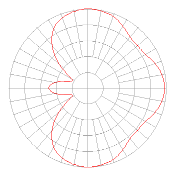 |
| Azimuth | Ratio | Azimuth | Ratio | Azimuth | Ratio | Azimuth | Ratio |
| 0 | 1.000 | 10 | 0.990 | 20 | 0.960 | 30 | 0.900 |
| 40 | 0.840 | 50 | 0.830 | 60 | 0.850 | 70 | 0.910 |
| 80 | 0.960 | 90 | 0.980 | 100 | 0.960 | 110 | 0.910 |
| 120 | 0.850 | 130 | 0.830 | 140 | 0.840 | 150 | 0.900 |
| 160 | 0.960 | 170 | 0.990 | 180 | 1.000 | 190 | 0.980 |
| 200 | 0.940 | 210 | 0.860 | 220 | 0.700 | 230 | 0.470 |
| 240 | 0.240 | 250 | 0.240 | 260 | 0.410 | 270 | 0.490 |
| 280 | 0.410 | 290 | 0.240 | 300 | 0.240 | 310 | 0.470 |
| 320 | 0.700 | 330 | 0.860 | 340 | 0.940 | 350 | 0.980 |
|
Structure Information
Structure Registration Number 1033919
Structure Type: GTOWER
Registered To:
UNIVERSITY OF WISCONSIN MADISON (DBA MADISON CANDELABRA TOWER)
Structure Address:
451 S. Pleasant View Road
Verona, WI
County Name: Dane County
ASR Issued: 05/22/2018
Date Built: 01/01/2019
Site Elevation: 343.2 m (1126 ft.)
Structure Height: 402.2 m (1320 ft.)
Height Overall: 433.7 m (1423 ft.)
Overall Height AMSL: 776.9 m (2549 ft.)
FAA Determination: 05/02/2018
FAA Study #: 2018-AGL-8179-OE
FAA Circular #: 70/7460-1L
Paint & Light FAA Chapters: 4, 9, 12
PRIOR STUDY 2009-AGL-2049-OE
43-03-21.0 N 89-32-06.0 W (NAD 83)
43-03-21.0 N 89-32-05.6 W
(Converted to NAD 27)
|
WKOW(DT) Licensee Information
Madison TV License Company, LLC
5727 Tokay Blvd
Madison, WI 53719
Phone: 608-273-2727
Limited Liability Company | 20061106ABC Applicant Information
Ralph M. Oakely
Date: 11/06/2006
Application Certifier
WKOW Television, Inc.
5727 Tokay Boulevard
Madison, WI 53719
Applicant
D. Scott Turpie
Lohnes and Culver
8309 Cherry Lane
Laurel, MD 20707-4830
Technical Consultant
Kenneth E. Satten
Wilkinson Barker Knauer LLP
2300 N Street, NW
Suite 700
Washington, DC 20037-1128
|
Associated Land Mobile Licenses
|
| (No Records Found) |
| Associated Microwave Licenses
|
| | KA74986 |
TV Pickup |
| | KA74988 |
TV Pickup |
| | WPNN714 |
18 GHz TV Studio Transmitter Link |
| | WPNN715 |
18 GHz TV Studio Transmitter Link |
| | WPOP489 |
18 GHz TV Studio Transmitter Link |
| | WPOP490 |
18 GHz TV Studio Transmitter Link |
|
