
FCCInfo.com
A Service of Cavell, Mertz & Associates, Inc.
(855) FCC-INFO
|
|
WRBJ-TV from 04/19/2011 WRBJ-TV from 03/31/2011 WRBJ-TV from 07/15/2004 WRBJ-TV from 04/26/2004 |
Virtual Channel 34 |
|
||||||||||||||||
|
|
Repacking Information: No changes Status: License Application Accepted: 05/11/2011 License Expires: 06/01/2021 File Number: BLCDT-20110511AGB Prefix Type: This is a License for a commercial digital TV station FCC Website Links: LMS Facility Details This Application Other WRBJ-TV Applications Including Superseded Applications Mailing Address Correspondence for WRBJ-TV Correspondence related to application BLCDT-20110511AGB Service Contour - Open Street Map or USGS Map (41 dBu) Service Contour - KML / Google Earth (41 dBu) Public Inspection Files Rabbit Ears Info Search for WRBJ-TV Site Location: 32-07-19.0 N 89-32-52.0 W (NAD 83) Site Location: 32-07-18.5 N 89-32-51.7 W (Converted to NAD 27) ERP: 968 kW Polarization: Horizontally polarized HAAT: 374.6 m (1229 ft.) Electrical Beam Tilt: 0.75 degrees R/C AGL: 378.7 m (1242 ft.) R/C AMSL: 501.2 m (1644 ft.) Site Elevation: 122.5 m. (402 ft.) Height Overall*: 388.6 m (1275 ft.) (* As Filed In This Application, may differ from ASR Data, Below.) Directional Antenna - Antenna Make/Model: DIELECTRIC TFU-31ETT-R 4C140 Antenna ID: 87818 Polarization: Horizontally polarized | ||||||||||||||||||
| Antenna Data for Antenna Id: 87818 WRBJ-TV DT File: BLCDT-20110511AGB DIELECTRIC - TFU-31ETT-R 4C140 Service: DT Standard Pattern: Y Pattern and Field Values Include a 120° Clockwise Rotation | 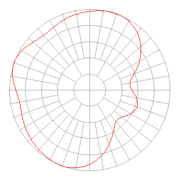 | ||||||||||||||||||
| Azimuth | Ratio | Azimuth | Ratio | Azimuth | Ratio | Azimuth | Ratio | ||||||||||||
| 0 | 0.971 | 10 | 0.991 | 20 | 1.000 | 30 | 0.979 | ||||||||||||
| 40 | 0.922 | 50 | 0.832 | 60 | 0.717 | 70 | 0.594 | ||||||||||||
| 80 | 0.511 | 90 | 0.524 | 100 | 0.592 | 110 | 0.627 | ||||||||||||
| 120 | 0.592 | 130 | 0.524 | 140 | 0.511 | 150 | 0.594 | ||||||||||||
| 160 | 0.717 | 170 | 0.832 | 180 | 0.922 | 190 | 0.979 | ||||||||||||
| 200 | 1.000 | 210 | 0.991 | 220 | 0.971 | 230 | 0.949 | ||||||||||||
| 240 | 0.923 | 250 | 0.893 | 260 | 0.883 | 270 | 0.915 | ||||||||||||
| 280 | 0.969 | 290 | 0.994 | 300 | 0.969 | 310 | 0.915 | ||||||||||||
| 320 | 0.883 | 330 | 0.893 | 340 | 0.923 | 350 | 0.949 | ||||||||||||
Structure Registration Number 1250734 Structure Type: GTOWER Registered To: EIP Communications I, LLC Structure Address: 475 Scr 481a Raleigh, MS County Name: Smith County ASR Issued: 11/30/2023 Date Built: 02/01/2006 Site Elevation: 122.5 m (402 ft.) Structure Height: 366.1 m (1201 ft.) Height Overall: 388.6 m (1275 ft.) Overall Height AMSL: 511.1 m (1677 ft.) FAA Determination: 07/02/2020 FAA Study #: 2020-ASO-5141-OE FAA Circular #: 70/7460-1L Paint & Light FAA Chapters: 3, 4, 5, 12 PRIOR STUDY 2005-ASO-2840-OE 32-07-19.0 N 89-32-52.0 W (NAD 83) 32-07-18.5 N 89-32-51.7 W (Converted to NAD 27) |
13600 Heritage Parkway Suite 200 Fort Worth, TX 76177 Phone: 855-826-2255 Not-for-Profit | Date: 05/11/2011 Application Certifier ROBERTS BROADCASTING COMPANY OF JACKSON, MS, LLC 1408 North Kingshighway Boulevard Suite 300 St. Louis, MO 63113 Applicant JOHN F.X. BROWNE P.E. John F.x. Browne & Associates Pc 38710 Woodward Ave., Suite 220 Bloomfield Hills, MI 48304 CONSULTING ENGINEER ROBERTS BROADCASTING COMPANY OF JACKSON, MS, LLC 1408 North Kingshighway Boulevard Suite 300 St. Louis, MO 63113 | |||||||||||||||||