
FCCInfo.com
A Service of Cavell, Mertz & Associates, Inc.
(855) FCC-INFO
|
|
|
Virtual Channel 43 |  |
|
|||||||||||||||||||||
|
|
Repacking Information: No changes Status: License Application Accepted: 05/02/2008 License Expires: 04/01/2022 File Number: BLCDT-20080502ABG Prefix Type: This is a License for a commercial digital TV station FCC Website Links: LMS Facility Details This Application Other KRWF Applications Including Superseded Applications Mailing Address Correspondence for KRWF Correspondence related to application BLCDT-20080502ABG Service Contour - Open Street Map or USGS Map (41 dBu) Service Contour - KML / Google Earth (41 dBu) Public Inspection Files Rabbit Ears Info Search for KRWF Site Location: 44-29-03.0 N 95-29-28.0 W (NAD 83) Site Location: 44-29-03.2 N 95-29-27.0 W (Converted to NAD 27) ERP: 58 kW Polarization: Horizontally polarized HAAT: 151 m (495 ft.) Electrical Beam Tilt: 0.75 degrees R/C AGL: 151 m (495 ft.) R/C AMSL: 481.1 m (1578 ft.) Site Elevation: 330.1 m. (1083 ft.) Height Overall*: 169.9 m (557 ft.) (* As Filed In This Application, may differ from ASR Data, Below.) Directional Antenna - Antenna Make/Model: Andrew ALP24M3-HSEC-27 Antenna ID: 85588 Polarization: Horizontally polarized | ||||||||||||||||||||||||
| Antenna Data for Antenna Id: 85588 KRWF DT File: BLCDT-20080502ABG Andrew - ALP24M3-HSEC-27 Service: DT Standard Pattern: Y | 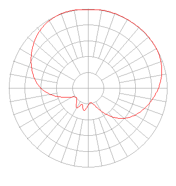 | ||||||||||||||||||||||||
| Azimuth | Ratio | Azimuth | Ratio | Azimuth | Ratio | Azimuth | Ratio | ||||||||||||||||||
| 0 | 0.990 | 10 | 0.999 | 20 | 1.000 | 30 | 0.999 | ||||||||||||||||||
| 40 | 0.999 | 50 | 0.999 | 60 | 0.996 | 70 | 0.979 | ||||||||||||||||||
| 80 | 0.944 | 90 | 0.890 | 100 | 0.826 | 110 | 0.758 | ||||||||||||||||||
| 120 | 0.687 | 130 | 0.597 | 140 | 0.476 | 150 | 0.340 | ||||||||||||||||||
| 160 | 0.229 | 170 | 0.188 | 180 | 0.222 | 190 | 0.287 | ||||||||||||||||||
| 200 | 0.222 | 210 | 0.287 | 220 | 0.222 | 230 | 0.188 | ||||||||||||||||||
| 240 | 0.229 | 250 | 0.340 | 260 | 0.476 | 270 | 0.597 | ||||||||||||||||||
| 280 | 0.687 | 290 | 0.758 | 300 | 0.826 | 310 | 0.890 | ||||||||||||||||||
| 320 | 0.944 | 330 | 0.979 | 340 | 0.996 | 350 | 0.999 | ||||||||||||||||||
Structure Registration Number 1024180 Structure Type: TOWER Registered To: KSAX-TV, INC. Structure Address: 5.8 Km. Ene Of Intersection Of Route 68 & 19 Redwood Falls, MN County Name: Redwood County ASR Issued: 05/02/2007 Date Built: 04/01/1987 Site Elevation: 330.1 m (1083 ft.) Structure Height: 168.7 m (553 ft.) Height Overall: 169.9 m (557 ft.) Overall Height AMSL: 500 m (1640 ft.) FAA Determination: 03/11/1987 FAA Study #: 84-AGL-2193-OE Paint & Light FAA Chapters: B, C, H HIGH INTENSITY WHITE LIGHTS 44-29-03.0 N 95-29-28.0 W (NAD 83) 44-29-03.2 N 95-29-27.0 W (Converted to NAD 27) |
3415 University Ave. St. Paul, MN 55114 Phone: 651-642-4372 Limited Liability Company | Date: 05/02/2008 Application Certifier KSAX-TV, INC. 3415 University Avenue, West St. Paul, MN 55114-2099 Applicant DICK RICE 3415 University Avenue, West St. Paul, MN 55114-2099 CHIEF ENGINEER DAVID A. O'CONNOR Holland & Knight Llp 2099 Pennsylvania Avenue, N.w. Suite 100 Washington, DC 20006-6801 | |||||||||||||||||||||||
| |||||||||||||||||||||||||