
FCCInfo.com
A Service of Cavell, Mertz & Associates, Inc.
(855) FCC-INFO
|
|
K47JC-D from 01/26/2004 |
|
|
||||||||||||||||
|
|
Status: License (Licensed And Silent) Application Accepted: 06/17/2008 License Expires: 04/01/2022 File Number: BLDTL-20080617AAI Prefix Type: This is BLDTL FCC Website Links: LMS Facility Details This Application Other K47JC-D Applications Including Superseded Applications Mailing Address Correspondence for K47JC-D Correspondence related to application BLDTL-20080617AAI Service Contour - Open Street Map or USGS Map (51 dBu) Service Contour - KML / Google Earth (51 dBu) Rabbit Ears Info Search for K47JC-D Site Location: 46-25-35.1 N 95-05-52.1 W (NAD 83) Site Location: 46-25-35.2 N 95-05-51.0 W (Converted to NAD 27) ERP: 2.25 kW R/C AGL: 55 m (180 ft.) R/C AMSL: 466.5 m (1531 ft.) Emission Mask: Simple Site Elevation: 411.5 m. (1350 ft.) Height Overall*: 99.1 m (325 ft.) (* As Filed In This Application, may differ from ASR Data, Below.) Directional Antenna - Antenna Make/Model: Scala SL-8 Antenna ID: 23503 | ||||||||||||||||||
| Antenna Data for Antenna Id: 23503 K47JC-D LD File: BLDTL-20080617AAI Scala - SL-8 Service: LD Standard Pattern: Y Pattern and Field Values Include a 130° Clockwise Rotation | 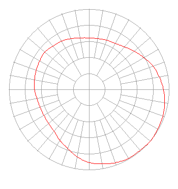 | ||||||||||||||||||
| Azimuth | Ratio | Azimuth | Ratio | Azimuth | Ratio | Azimuth | Ratio | ||||||||||||
| 0 | 0.640 | 10 | 0.640 | 20 | 0.650 | 30 | 0.660 | ||||||||||||
| 40 | 0.690 | 50 | 0.740 | 60 | 0.790 | 70 | 0.850 | ||||||||||||
| 80 | 0.890 | 90 | 0.930 | 100 | 0.960 | 110 | 0.980 | ||||||||||||
| 120 | 0.990 | 130 | 1.000 | 140 | 0.990 | 150 | 0.990 | ||||||||||||
| 160 | 0.970 | 170 | 0.940 | 180 | 0.910 | 190 | 0.850 | ||||||||||||
| 200 | 0.780 | 210 | 0.730 | 220 | 0.680 | 230 | 0.660 | ||||||||||||
| 240 | 0.650 | 250 | 0.650 | 260 | 0.660 | 270 | 0.680 | ||||||||||||
| 280 | 0.690 | 290 | 0.700 | 300 | 0.710 | 310 | 0.720 | ||||||||||||
| 320 | 0.700 | 330 | 0.690 | 340 | 0.670 | 350 | 0.650 | ||||||||||||
Structure Registration Number 1216042 Structure Type: TOWER Registered To: SBA Structures, LLC Structure Address: 13921 Oink Joint Road, Wadena, Mn 56482 Wadena, MN County Name: Wadena County ASR Issued: 04/26/2013 Date Built: 01/29/2001 Site Elevation: 411.5 m (1350 ft.) Structure Height: 91.4 m (300 ft.) Height Overall: 99.1 m (325 ft.) Overall Height AMSL: 510.6 m (1675 ft.) FAA Determination: 01/29/2001 FAA Study #: 00-AGL-9835-OE FAA Circular #: 70/7460-1K Paint & Light FAA Chapters: 4, 8, 12 PRIOR STUDY 00-AGL-6062-OE 46-25-35.1 N 95-05-52.1 W (NAD 83) 46-25-35.2 N 95-05-51.0 W (Converted to NAD 27) |
Hurst, TX 76054 Phone: 214-770-7770 Corporation | Date: 06/17/2008 Application Certifier THREE ANGELS BROADCASTING NETWORK, INC. P O Box 220 West Frankfort, IL 62896-0220 Applicant DANIEL N. PEEK Po Box 220 West Frankfort, IL 62896-0220 ENGINEER MOSES PRIMO 3abn | |||||||||||||||||