
FCCInfo.com
A Service of Cavell, Mertz & Associates, Inc.
(855) FCC-INFO
|
|
WPNT from 04/17/2006 WPNT from 01/13/1998 WPNT from 09/12/1978 |
Post-repack Channel 21 Virtual Channel 22 |
|
|||||||||||||||||||
|
|
Repacking Information: Pre-Repack Channel: 42 Post-Repack Channel: 21 Post-Repack ERP: 645 kW Phase: 7 Completion Deadline: 1/17/2020 Other Linked Stations Find nearby TV Facilities Status: License Application Accepted: 12/20/2023 License Expires: 08/01/2023 File Number: -0000233496 FCC Website Links: LMS Facility Details This Application Other WPNT Applications Including Superseded Applications Mailing Address Correspondence for WPNT Correspondence related to application -0000233496 Service Contour - Open Street Map or USGS Map (41 dBu) Service Contour - KML / Google Earth (41 dBu) Public Inspection Files Rabbit Ears Info Search for WPNT Site Location: 40-29-43.0 N 80-00-16.0 W (NAD 83) Site Location: 40-29-42.8 N 80-00-16.8 W (Converted to NAD 27) ERP: 721 kW Polarization: Elliptically polarized HAAT: 312 m (1024 ft.) Electrical Beam Tilt: 0.75 degrees R/C AGL: 218.7 m (718 ft.) R/C AMSL: 620.7 m (2036 ft.) Site Elevation: 402 m. (1319 ft.) Height Overall*: 222.5 m (730 ft.) (* As Filed In This Application, may differ from ASR Data, Below.) Directional Antenna - Antenna Make/Model: Dielectric TFU-14JTT/VP-R 3C190 Antenna ID: 1006799 Polarization: Elliptically polarized | |||||||||||||||||||||
| Antenna Data for Antenna Id: 1006799 WPNT DT File: -0000233496 Dielectric - TFU-14JTT/VP-R 3C190 Service: DT Standard Pattern: N | 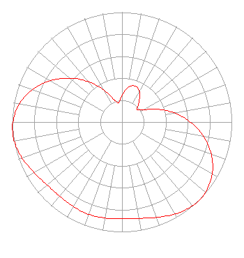 | |||||||||||||||||||||
| Azimuth | Ratio | Azimuth | Ratio | Azimuth | Ratio | Azimuth | Ratio | |||||||||||||||
| 0 | 0.242 | 10 | 0.319 | 20 | 0.349 | 30 | 0.319 | |||||||||||||||
| 40 | 0.242 | 50 | 0.178 | 60 | 0.222 | 70 | 0.342 | |||||||||||||||
| 80 | 0.482 | 90 | 0.622 | 100 | 0.753 | 110 | 0.866 | |||||||||||||||
| 120 | 0.949 | 130 | 0.993 | 135 | 1.000 | 140 | 0.997 | |||||||||||||||
| 150 | 0.967 | 160 | 0.924 | 170 | 0.891 | 180 | 0.882 | |||||||||||||||
| 190 | 0.888 | 200 | 0.893 | 210 | 0.888 | 220 | 0.882 | |||||||||||||||
| 230 | 0.891 | 240 | 0.924 | 250 | 0.967 | 260 | 0.997 | |||||||||||||||
| 263 | 1.000 | 270 | 0.993 | 280 | 0.949 | 290 | 0.866 | |||||||||||||||
| 300 | 0.753 | 310 | 0.622 | 320 | 0.482 | 330 | 0.342 | |||||||||||||||
| 340 | 0.222 | 350 | 0.178 | |||||||||||||||||||
Structure Registration Number 1026131 Structure Type: TOWER Registered To: Gerstell Development Limited Partnership Structure Address: 750 Ivory Ave Pittsburgh, PA County Name: Allegheny County ASR Issued: 01/30/2001 Date Built: 10/26/1996 Site Elevation: 402 m (1319 ft.) Structure Height: 196.6 m (645 ft.) Height Overall: 222.5 m (730 ft.) Overall Height AMSL: 624.5 m (2049 ft.) FAA Determination: 01/25/1994 FAA Study #: 93-AEA-1277-OE FAA Circular #: 70/7460-1H Paint & Light FAA Chapters: 3, 4, 5, 13 40-29-43.0 N 80-00-16.0 W (NAD 83) 40-29-42.8 N 80-00-16.8 W (Converted to NAD 27) |
1200 Seventeenth Street, Nw Washington, DC 20036 Phone: 202-663-8195 Limited Liability Company | Title: Evp And Cfo, Sinclair, Inc Date: 12/20/2023 Application Certifier WCWB Licensee, LLC Wcwb Licensee, Llc 1200 Seventeenth Street, Nw Washington, DC 20036 Applicant Kevin Fisher Smith And Fisher, Llc 4791 Wintergreen Court Woodbridge, VA 22192 Miles S. Mason, Esq Pillsbury Winthrop Shaw Pittman Llp 1200 Seventeenth Street, Nw Washington, DC 20036 | ||||||||||||||||||||
| ||||||||||||||||||||||
